Thursday 30 July 2015

Days 9-14

Day 9 was the first day that Stuart and I went our own ways.  It was also the 1st Munro of the journey and I was lucky enough to have Richard Bannister with me.  

The navigation should be a bit more straightforward from here onwards, in many respects. Having done a lot of compass work in preparation for the trip it hadn't really come in useful whilst we'd been running on roads or through forests.  I was looking forward to setting a bearing and trying to stick to it.  

We've had a relatively gentle start since Peel Fell; although the borders had a lot of climbing within them, most days were shorter than 15 miles.  By the time we were running through the central belt on roads we had a far greater mileage but there wasn't so much climbing.  From this point onwards there is both.  

Stuart and I had reccied the first part of day 9 so I knew what to expect.  Having run along the side of Loch Lomond on the West Highland Way numerous times and felt it was tough with all the undulations, I can confirm, going a little further east onto the watershed is substantially worse! 

The ground here is incredibly boggy and tussocky as well as the hills being very rolling and indistinct.  This makes it hard to gauge progress although that's maybe good as it's incredibly slow through the terrain.  

I've been trying to keep a daily tab on how many times I fall over but Richard and I lost count between us and felt we had to re-define a fall so we could keep track; A fall includes hands as well as knees on the ground.  And we still lost count...

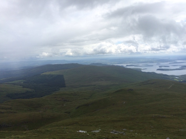
On the plus side the weather was beautiful.  Apart from a couple of heavy showers we had great views. Ben Lomond took far longer an expected to appear but it finally did so, revealing a snake of people up the path.  After hours of only Richard for company it felt almost city like!
What looked on the map like an easy finish to the day was interrupted by an innocuous looking kilometre under some power lines, leading to the road.  This was an awful tramp through particularly lumpy heather and managed to put a dampner on the day.  


The following day was considerably tougher with 4 Munros; Ben Chabair, An Caisteal, Beinn a' Chroin and Cruach Ardrain.  Stuart Chalmers joined us for the day and to make it a bit tougher for himself he ran to the Inversnaid bunkhouse, where we stayed, from Bein Glas farm!

We were in cloud for most of the day so had to keep a close eye on the GPS and maps.  It was really nice to share the navigation and discuss route options - should we stick to the path or avoid extra descent by cross-countrying it a bit?  The paths always led us astray, despite being so enjoyable to run on.

Occasionally the cloud lifted and we could see where we were heading but it was mentally exhausting getting round this loop.  It was the biggest climbing day of the trip so far with between 2000 and 3000 metres of climbing, depending who's watch you believe! 

Day 12 has perhaps my favourite day to date.  Although the first 5 miles were through difficult terrain the midges kept us going and we got to the Munros quickly.  

This day we had Beinn Dubhcraig, Ben Oss and Ben Lui.  From the top of the first Munro the cloud thinned out so that we could see our route spread out in front of us.  For the rest of the day the cloud swirled lightly around us and we had plenty of blue sky and sunshine which was very energising.  

I've had to turn away from Ben Lui a couple of times in the past because of the weather; it has a very exposed descent and would have been precarious without good visibility.  In the conditions we had however, it was stunning.  

It was only when I got to a shower I remembered the midges from earlier.  My skin was like a midge graveyard and a crowd of them had managed to work into the seams of my clothes and nibble little lines around my limbs! 

Over the weekend we had more company.  Angela, Ruth and Lorna came to join us.  Angela didn't fancy running with us but it was lovely to have her company in the evenings.  

We had another stunning day (apart from the hail!) and it was remarkably easy going over Beinn Achaladair and Beinn A' Chreachinn.  The descent was the only point I felt Ruth and Lorna got a real sense of the watershed, running over bog and bracken.  We also had to make a big river crossing to get to the support van and Ruth managed to fall in, much to our amusement.  It was such a tricky descent that I lost count of our falls again but I'm pretty sure that Ruth won.
Lorna was kind enough to bring her massage couch with her and gave me a great massage at the end of the day.  Just what I needed.

It was just Ruth and I running on Sunday. Richard had originally planned to do 4 days of the watershed challenge.  I'm not sure if it was my company or the lure of the Watershed but he decided to come back for another 4 days and used Sunday to go back home and collect more kit.  

It was a very easy day and a great chance for me to get my head around the logistics for the next few days which will be unsupported.  These last few days have been what I hoped for from their journey - a brilliant mix of climbing and terrain.  It's never been too much of one thing, though I'm ready to get onto a new map sheet after being in the same one for 3 days now!  Navigation has been pretty successful which is encouraging.

It's not the greatest selection of photos I'm afraid, I've had real trouble doing this at all and Tom has had to help from home, without access to my photos! Just downloaded the blogger app so things may improve now.

Monday 27 July 2015

Days 6-8

Days 6-8 of the watershed goes through the central belt. This creates a problem if we were to stick exactly to the route as there are farms, houses and Cumbernauld in the way! The route we took instead 'follows' the watershed but sticks to nearby roads. This meant we were able to cover bigger miles and the going was a lot easier.


Having been on such remote terrain it was strange to be so close to civilisation all the time. The biggest positive about this is there were very few midges due to the pollution! 

The best bit about heading through the central belt was the opportunity to see friends and family. Emily and Emma as well as Stuart's wife Linda came to join our support crew of Amanda and Brian and this was a real boost. We even stayed in our respective homes for a few nights which was great recuperation and an opportunity to do some washing. 

I enjoyed running through 2 OS maps, It made me felt we were making great progress. At this stage we headed north where as a lot of the first 5 days we were heading west. Luckily this didn't feel too indirect at the time as we focused on such small sections at a time but when you look at the whole picture, we hadn't moved towards Duncansby Head much!

However, it wasn't all easy. We had various sections which were very recognisable as the watershed; on day 6 we crossed the southern part of the Pentlands. Somehow, being central and a popular walking area I expected this to be straightforward but it's evidently not a popular area. There were very few paths and particularly unpleasant tussocky heather and bracken to trip us up.

As we passed through Kilsyth we had a big entourage cheering us through so we stopped for coffee and cake with my mum, nephew, Amanda, Brian, Linda and Maisie from Funding Neuro.


We experienced our worst weather at this point, not only was the rain belting down but it was very windy and both Stuart and I were cold and demoralised by the time we were collected.

Having run for a week together Stuart and I were realising that we weren't very compatible as running partners and a few nights at home allowed Stuart to make the decision to do his own thing. 

I will continue running the watershed and I aim to stick to our original plan as much as I can. 


Sunday 26 July 2015

We've finished section 1 already! It might not have been a week yet but the 'Revier March' as Peter Wright refers to it, extends from the borders to the central belt. It feels like the end of a section for me anyway, partly as we've done a very hilly chunk in the borders and now for the next few days we're farm dodging along roads with far less climbing so will be a different type of toughness. The last thing that changes for this section is our support driver. Tom has been with us for the first week but now he's off home and I expect that will make the next few weeks a little harder.

This has been such a long anticipated trip and so thoroughly thought through I hadn't really had any time to think through how I might feel on the trip. Would it be exhausting? Will the sun shine at all? Will we navigate successfully? Needless to say it's a big mix of the above and best of all it's been really enjoyable so far. 

The terrain has been far better than I had dared hope and has been largely runnable. The 1st 3 days crossed forests which I was dreading as we knew there had been substantial changes in the area. Although I'd reccied the 1st section with Emily earlier in the year, a crucial turning had disappeared and meant we spent a long and anxious time wading through felled trees with precarious branches sticking up and mud baths in between, it was a soul destroying 40 minutes covering very little ground and combined with the continuous rain we saw throughout the day was very demoralising.


The plus side of the first day was that there were 2 access points for us to be cheered on at and I was grateful to see the van so I could put on new trainers - within half a day I managed to destroy a relatively new pair.
We ended up being out for around 10 hours which was far longer than expected and fairly dispiriting. It was around 3 miles longer than planned and although not necessarily harder than anticipated, we definitely saw it at its worse. 

Day 2 was a slightly cheerier start and was much shorter than the first day. We had a lot more forest to contend with though and within the 1st couple of hours it burst our bubble of hope for an easier day. We had to use Stuart's gps as we needed the 1:250000 detail to decipher little forest breaks where we could get in to the forest and try and navigate through. It was a difficult approach to the forest through very tussocky ground, covered in heather and we both managed a few falls. 

It was no relief to get into the forest as Stuart's GPS started misbehaving and the breaks weren't as clear or as simple as they appeared on the map. 

Over this section we couldn't follow the true watershed too closely as it's impossible to cut through the forest unless on the paths or breaks. Since we weren't on the watershed anyway I suggested deviating from the planned route and cutting into very clear paths. 

I think Stuart may have come up with numerous ways to kill me as we clambered over rotting wood, slipping and sliding, ducked under branches and generally tumbled through forest for quarter of an hour. Luckily for me it paid off and we found ourselves on a very easy fire track. The sun burst trough in celebration and we were toasted throughout the afternoon. 

The fire track wasn't too direct but saved us a lot of time and we ran straight to our accomodation at the Samye Ling Buddhist centre. The grounds are lovely but I was quite keen to rest my legs so didn't explore too thoroughly.


Day 3 was the last day with any forest and it started promisingly in the sunshine. Tom ran the first few kilometres with us which was particularly good as he found the bridge that both Stuart and I were searching for at different points of the river.

After that navigation was straightforward and the paths were the same as printed on the map which made for an easy morning. There was a slightly dicey moment where tree felling was happening right on the path that we had to cross and it really is the most terrifying machine that can slice straight though an entire tree without problem. We were enough of a novelty for the workers to stop and chat rather than reprimand us.

There were some more overly exciting trail breaking before we finally left the forest behind and got onto an open ridge. Originally we'd planned to leave out some of these smaller peaks as it seemed prudent to save our legs a little at this stage. However, it didn't take long to realise that the ridge was much easier on our ankles and there was a very fine dry stone wall to keep us on track. 


A lot of the watershed coincides with historic borders which are still marked with fences or walls and this helps navigation a lot. Pleasingly there had obviously been a quad bike in the area which had also followed the watershed, this made the going even easier for us. Curiously the quad bike trails jumped from one side of the wall to the other numerous times along the way, I can only assume that quad bikes fly in the borders.


On Thursday we were similarly rewarded with an easy to navigate ridge and largely manageable underfoot. To get us from our starting point onto the ridge we followed a decent path up beside the grey mares tail falls. This provided us with stunning scenery and was easy going, apart from the climbing of course, until we reached loch Skeen where we had some classic watershed bog to wade through.
Despite a lot of climbing during the day the weather turned out far better than expected, it was a pleasingly straightforward day and morale was high. Wildlife was scarce but for the 1st time since we started we saw other people! 5 in total, it almost felt like we were missing the true watershed experience with human contact like this. 

The final day of the Reiver March had an awful weather forecast. Heavy rain and high winds were not appealling. The start of the day also involved more modified forests with a windmill farm for added confusion. We had the most dreich first couple of hours, improved only by the fact that we followed a decent path which coincided with what was on the maps. 

I think we got a little cocky with this however and stuck to the path longer than we should have. By the time we realised this we were on the wrong side of a small valley and it was hard work correcting our mistake. If there's one thing I've learnt this week, it's not to trust paths. The sad truth is, on an adventure like the watershed, they're very unlikely to lead you to where you plan on going. Although this isn't true of the ridges, through forest and field we've been led astray too many times this week! 

After this minor correction we followed tractor trails for the next few little peaks. I kept a close eye on the GPS and took careful bearings and we had a very successful afternoon. The weather improved substantially and we didn't have to wear waterproofs all day long! We finished in a shorter time than expected and in high spirits as a result.
During our first five days we've accumulated 94.8 miles and climbed 5094 metres. Despite falling numerous times the watershed has so far been more enjoyable and manageable than I imagined. Even in the rain it's been mostly lovely and we've not been too hounded by midges yet. Let's hope it carries on as well as this.

Recces, training and blethering

The watershed adventure is getting closer and the training is building up! The last few weeks have been a great mixture of recces, races, fundraising, navigational sessions and serious training.
I decided a few weeks ago to approach a coach as I was starting to feel quite unsure about my training schedule. Initially I had been building up the miles following a similar plan to last year when I was preparing for the West Highland Way race as I felt really strong for the event and made a quick recovery. However, I'm slowly starting to realise that I've taken on something far more epic and hugely different to anything I've done before. I approached Donnie Campbell as I know he has a lot of experience with ultra runners and so went to Edinburgh to meet him. I have no idea what he thinks of our trip, he has a great poker face and was very direct in telling me what to do. Build up my miles. This shouldn't have been too much of a surprise as I'm training to run roughly 120 miles a week whilst at the moment I normally do around 50.  Needless to say this revelation has coincided with a busy time at work so my social life will need to take a back seat for a while...

I was racing the Cateran 55 the weekend after meeting Donnie so he promised me an easy week the following week. I didn't have high expectations for the Cateran race. It was only 3 weeks after the Highland Fling and I've never done ultra races so close together. I was determined that this should be a slow training run and that I should feel ok at the end as Donnie had instructed me to run the following day.  I had a brilliant first half, I really kept to my plan and trotted along, blethering with other racers and resisting the temptation to try and keep up with Ali Wyllie who I ran the entire Catern with last time.  By the half way point I was oblivious to where I was within the field, it had fairly spread out but I was feeling great and aware that I was overtaking a few people and so was very happy with my pacing.  At the Bridge of Cally checkpoint I arrived to see Ali and Johnny Fling leaving and I thought, wow, I've paced this incredibly well if I've managed to catch them up! I had a spot of faffing to do at the check point and left with them in my sights although it took a while to actually catch Ali, despite her turning round and telling me to get a move on several times! When I did she told me I was now 2nd female. The game changed... I've never made the podium in an ultra race and the prospect was very exciting.  It felt a bit strange to be racing Ali like this, however, we did have a brief chat on how we'd be very happy sharing the podium, regardless which way round we were. I've so much respect for Ali and she's such a great runner I'd be very happy for her to get ahead of me. If we'd been competing for 3rd and 4th place maybe it would have been different! Anyway, we didn't know where number 4 was so with about 18 miles to go we both really pushed to keep ahead. I opened a bit of a gap but I could always see Ali behind me. The final climb of the race is brutal, I remember the last time I ran the Cateran, I couldn't run any of the ascent, Ali had tried to get me moving at this bit but I was broken. It was so satisfying to be able to keep running bits of it this time. I could see Ali gaining on me, she was climbing much faster than I could and by the time we finally got to the top I knew I couldn't stay ahead but she was within bellowing distance and yelled 'get a move on, my knees buggered!'. With a sore knee she was going to struggle downhill so with the finish in sight I shuffled down as fast as I could. I finished 2nd female, 12th overall with a time of 10hrs 2mins which surpassed all my expectations, and my mums apparently - she missed my triumphant finish.  

I was just about on form for a further shuffle the following day, it was a very slow 10km, made slower by cows and mud but I was running bits of it, satisfyingly. 
My 'easy' week then involved getting 2 more 16km runs in, a tempo 12km and a 40km run.  Without wanting to dispense my social life entirely I engineered my runs to involve a navigation course, meeting up with Emily, and running to a party.  
The navigation course with Gary Tompsett was great and Stuart and I are very grateful to all the time and wisdom he has given us in preparing for navigating the watershed.  We covered a bit of the watershed near Coulter and I was really pleased with how confident I felt. I'm much better at interpreting contours now but a weakness I still have is not understanding from looking at a map what I will be able to see in the distance.  Just because there are contours depicting hills it doesn't mean that they will all be visible from where I stand.  Gary was disappointed the weather was so good as he felt it was a bit easy for us! Between Stuart and I we spend a bit too much time discussing our optimal route, checking between map and GPS.  We need to learn to be more efficient as we waste so much time doing this and I started to get a bit cold despite the weather being fairly mild.  It was also really useful to have Gary as a neutral party suggesting how we work our different strengths and cope with our different paces.  I realise that I'm a bit of a control freak and I like having control of the map.  Having a bit of time waiting for Stuart gives me time to check what I'm doing continually and allows me to make sensible, accurate decisions.  However, that puts me under a lot of pressure to get the navigation correct otherwise Stuart will be justified in getting fairly pissed off every time I make a mistake so it's important that we can work in a way that will allow us both to feel involved and responsible.  I'm not sure what the ultimate solution is yet but it's another of many things we need to solve before mid-July. 
Later in the week Emily was a huge help on my tempo run by cycling ahead of me and making me work hard and keep up the pace.  In order to attend my mum's Birthday celebrations I ran to Falkirk with my glad rags in my new rucksack. Although it was a very flat run my heavy bag made me feel it was useful training. The weather caught me out surprisingly, it was a beautiful day and my right hand side was very burnt by the time I arrived! Mum had decided to have quite a big do and requested that people didn't bring her a present but instead donated to Funding Neuro.  This incredible gesture brought in another £500 for the charity and I'm very grateful to everyone who donated and to my Mums great idea and selflessness. 
All in all it felt a tough week, my quads felt tight and my whole body was tired but after one day off before the run to Falkirk I felt much better and pretty strong over all. 

Elspeth and Emily recce Peel Fell section. 11th-12th April 2015

I'm really keen to reccie  all the southern part of the watershed for a number of reasons; it would be too soul destroying to get lost on the first day, the forestry has changed dramatically since the most recent OS map was produced and lastly, I don't want to be too shocked at the beginning of our adventure.Emily and I headed down to the borders to do some exploring. We planned on walking rather than running as Emily is still injured after a bad fall. The experiences we had over the weekend made me come up with a run-ability scale, 10 being knee deep bog or seriously large bouncy tussocks, impossible to run on, 5 being ankle deep bogs with dry sections and partly runnable and 1 being farm track, easily runnable.
I hadn't had a whole lot of time to choose a route carefully and as we were only taking 1 vehicle it was going to be out and back routes. We left later than planned on Saturday and didn't start walking until after 1. We parked near Rushy Rig and walked to the top of Peel Fell and back. This was really straight forward navigationally and the first 3 miles are on easy track. I had noted a junction on the map so as soon as we got to one I concluded we should turn off to the right.
The path was less defined than I had hoped so I took a bearing and was really confused when it showed I should be going 180 degrees in the opposite direction. I was so unwilling to go against my instinct but I had promised myself only a week ago that I must learn to trust the compass and it actually paid off! Less than 100 metres further on we found a much more distinct track! I'm finally learning from my experiences. The track seems to stop at Wheelrig Head on the map, the forestry has changed a lot here but there is still a clear track right to the edge of the forest, as it's marked on the map. It's not easy going though and disappears entirely by the top of the burns. It's easy to follow a bearing here to the summit but the path deteriorates to a 9 on the run-ability scale at points.

We had an easier time than we may in the summer as it's been very dry this last week and so there were crossing points through bog, I'm preparing myself for a really soggy time here! We posed for a photo by the cairn and unusually I thought to double check that we were where we had assumed. And guess what, we weren't! Who'd have thought there were 2 summits on this hill? The real summit was close by so we went there too. On Sunday we woke up having not had a great sleep due to the van being buffeted around by the wind and pelted with rain, snow and hail. It sounded foul outside and if the van contained a toilet we'd probably never have got started. However, nature forced us out and we braved the elements.
Today I was following a printed section of the map as we were crossing between 2 OS sheets and I didn't want to have to take both of them. The trouble with this is that although the original watershed is clearly marked, as well as our planned alternative, the marked lines obliterate a few key map symbols. It looked to me that we would be spending a lot of the day finding alternatives to crawling through forest. We picked up a path off the road, directly opposite the Rushy Rig track. This was a 6 on the run-ability scale although the snow at this point made the going a bit more precarious for us. We followed a fence line up hill. Despite having clear routes on the map to follow I wanted to see where the path would take us because the alternative would have been hellish tramping over recently felled forest. We actually found ourselves right at Wigg Knowe on the original watershed and were able to follow the fence South west, along the forest edge. The track has been used here but is very boggy and a 7 on the scale.
The forest to the south of the path here has been felled but old forest has been left from just beyond the trig point on Fanna Hill. Where the forest South of the path has a sharp corner heading South East the Northern part of the forest has been felled too. However there is still a fence to follow along this gentle ridge. I was unsure on how we were going to find a way through the forest onto the track at Laidlehope Head and so when I saw a line between new and old forestry (558018) I suggested we followed it down. It was still a 7 in terms of terrain but took us directly to the path.
My smugness didn't last long however as we arrived shortly after this at a junction which wasn't on my map. It was marked on the OS phone map so it was easy to clarify and after establishing that we should go right we headed round to the left. Emily did ask if I was sure of the direction but wasn't more detailed as to her confusion and it was a whole km later that I realised what I'd done. It was the simplest bit of navigation the whole weekend and I screwed up for no apparent reason! After we had retraced our steps the going was straight forward ( a 1 on the scale!) and there were no more events on the track.
On the return I was keen to try an alternative line through the trees so when we got to the junction of applied idiocy we followed a fence line East East South, (the suggested line on our route planning and I suspect it was obliterating a marked path). There was definitely evidence of a path, possibly elevating this route to a 6 on the scale and it was clear to follow along an old fence line. It is also clear to find from the top too as there is a junction in the fence and a gate into the next field. It was amazing to see the differences on the route throughout the day, we started in heavy snow which was lying thickly but by the way back we were in bright sunshine and the snow had largely gone. I can only hope we will have a long dry spell before a Stuart and I tackle this first day...

Recce above Tyndrum. Three Munros; Beinn Dubhcraig, Ben Oss and Ben Lui. March 2015

This week Stuart and I went over our maps and made a careful plan of what we thought would be manageable and enjoyable when we tackle the Watershed. We've made some minor alterations which don't take away from the spirit of the route but which will cut down on some of the less exciting hills and bumps and the potentially frustrating farmland. We also chose some back up routes for the epic days where we may run out of time and steam. As a result of this I decided to do a recce on a section that we may exclude, above Tyndrum.
Given there are so many sections that we do need to recce this may seem like an odd choice but I wanted to see what this section would be like on fresh legs and then consider if our alternative was sensible. It also gave me the opportunity to cover a section of the watershed which we may miss out. Ultimately, I would like to cover as much of it as I can, even if it's not connected to our main challenge.

Our planned day 12 (or thereabouts) is to start at Crianlarich and do a semi circular route, which loops back to Tyndrum. This takes in 3 munros; Beinn Dubhchraig, Ben Oss and Ben Lui. It's about 27km in length and climbs 2624m. I'm imagining that we're going to be hard as nails by this point and this will be a wee walk in the park but just incase we're a little tired we have the option of cutting down to a track after Ben Lui and sticking to it into Tyndrum. This won't have a huge impact on distance or elevation gain but will be a much quicker last section as it is on a track.
So this is the section Tom and I chose to do. It was convenient for a number of reasons and was a great section to practice some navigation and test out kit. We were walking today and so were not testing any running clothing but I've just uploaded OS maps onto my phone and was keen to see how reliable they are.
We wore walking boots which were great on all the gnarly ground. Generally I hate the weight of walking boots but I was glad to be wearing them today. I tested my navigation along the way by trying to see if I could pinpoint my exact location on the map and checked with my phone. I used my GPS watch to check my height for this and tried to pick up various natural features. The first few times I was around 200 metres out. It wasn't going to be disastrous on a clear day like today but not ideal either. Neither the watch or the phone maps are perfect, we could see from one of the smaller summits we climbed today that my watch is around 5 metres out at times.
The phone's location on the map is represented by an oversized dot which actually takes up a tenth of the km box, meaning that it can only pinpoint you within 100 square metres. Unlikely to be disastrous but worth noting. My first mistake happened coming off an unnamed summit towards Creag Bhuide. I'm ashamed to admit this as I made a classic mistake that Gary warned us about on both navigational courses. I took a bearing, ignored it and went with my gut instinct instead, which of course was wrong. The reason I assumed I was right over my compass was that we were following an old boundary which is still easy to see, there are lots of fence posts, old fence wire and evidence of a wall. It's just that it's not the boundary shown on the map.... I will learn from this mistake this time!
It wasn't a big deal during today's walk as I realised within 300 metres and could get back to our intended route. We had to cut through a forest to get to the start of the Bein Chuirn ascent. The forest wasn't too dense so was easy to get through and it was a thin enough section that we weren't disorientated. The deer fence at the bottom was the most awkward thing actually. From here we could see the Corbett was still very snowy and we were approaching it from its steepest, craggiest side. We walked round the side of the hill (on an excellent bearing which we didn't drift from at all) and investigated the south eastern slope which was a bit more accessible. It was a tough climb and I realised that although I may have managed a 33 mile race last weekend, I have a lot of hill training to do!
The sun came out for us and we had a brilliant view from the top, Ben Lui stayed slightly hidden in the clouds but we could see enough to realise that it was a no go without crampons. I had a surprising discovery with a 1:50 000 scale map whilst we were at the top of Bein Churin. We passed a dramatic re entrant that looked innocuous on the map but was definitely a climbers gulley and not a runners. It still had snow clinging to the side and would have been completely concealed when the snow was heavier. Despite using this scale of map most of the time I realise that I must generally be following routes or trails so haven't realised how indistinct precarious sections can look on a map. Lesson learned, for at least 5 minutes anyway.
We opted for an easier, shallower descent along the shoulder south of the hill. We hand-railed (or handle-barred, as Tom called it) a stream but were obviously paying less attention than we had been to the map as we ended up right above a waterfall, not descendable without ropes or a death wish! I was annoyed to have got into this position as I had just made a mental note to avoid steep craggy sections but I wasn't paying close enough attention to realise exactly where we were. So instead of a gentle descent we then had to follow the steep slope that we had climbed up on, not fun. This took us to the track that Stuart and I think may be a sensible route in the summer and it was one of the few runnable moments of the day.
The rest of the walk had been so undulating and steep in places that very little of it would have been easy to run. I was pleased by how much less boggy it was than I had imagined. I have started to worry that our challenge is taking on a lot of unpleasant elements, such as huge amounts of bog, tricky navigation, difficult terrain and a lot of climbing, but this small section today reminded me why I want to run the watershed. It was spectacular and felt very remote, rugged and beautiful.
I feel really lucky that I have the ability to explore places like this and am really looking forward to the rest of the Watershed experience.


Recce in the Campsies that covered Holehead and Dungoil

My friend, Elizabeth Adams, and I did a wee loop in the Campsies that covered Holehead and Dungoil. It was a section of the route that had bail out spots and also options to extend as I was under time pressure and knew there was a distinct chance of getting lost. However, owing to such a useful navigation session last week I could pinpoint exactly where we were on the map for the whole outing!The cloud was low and visibility was really poor when we started so it was hard to look for landmarks to walk on a bearing to. I was checking the compass every few hundred metres. I had guesstimated the time it would take us to get to the top; I really need to get into the habit of this to help improve my navigation. Remarkably I was almost spot on which was very satisfying.
As Stuart and I had experienced before, the area we were running in through the Campsies is quite featureless and very difficult to navigate with poor visibility. Keeping on top of bearings and what distance we had travelled was particularly important on this run. I tried to use contours to indicate where we were and this worked well as we used a 1:250000 map. Contours are less useful over a small area on a 1:50000 map. I was also careful to note where we could hear streams and see fences and really tried to collect clues as Gary Tompsett had suggested.
I was a little annoyed to cross a stream at one point, running the Watershed should mean going between streams and rivers, not over! Under the circumstances I was very pleased with our accuracy however. We had to run into a forest after Holehead. This can often cause problems as paths seem to change frequently through forests and crawling under an coniferous canopy does not strike me as fun or efficient. I've also come to realise that forest boundaries are very unreliable to navigate by, if I'd learnt that years ago it would have saved me a lot of grief on many occasions! The obvious place into the forest was following a stream, there was a good clearing surrounding it and according to the map it should lead to a fire track within 100 metres. It did indeed and there was more back patting. There was also a red herring in the form of a disused sheepfold. There is one marked on the map but it is marked at 622 842 and I thought we were at 624 838. So, either we had entered the forest by an unmarked stream and had navigated off the hill not as well as I had thought, or there was a second sheepfold. This is usually the moment that I toss the map away and admit defeat. 'How can we not be where I thought when I'd been so careful!! I must be wrong because there's a sheepfold right here!!' At Elizabeth's calm suggestion we followed the path anyway and made note that it was heading northwest. This would have been feasible from the sheepfold marked on the map or from where I had thought we were. By doing this we collected more clues and happily were able to conclude that navigation had been spot on and the map was missing a minor feature. Don't rely on man made features!! Lesson learnt.
For the rest of our outing the map did exactly what I hoped it would although we still had some difficulties because of the forest. There is a small path marked on the map through the forest from the fire track to Dumgoil. Had I not made careful note that we had to look for it 100m after a bend we would have run past it as it's very discreet and there are a lot of young trees hiding it. After this we got to the top of the hill easily enough. I had to check we were at the summit with my watch as it the whole hill top is quite lumpy ground so I wanted to check the mist wasn't covering the main lump!
Getting off the hill and going the direction we needed turned out to impossible because of the density of the trees when we reached the forest again. We spent a short while looking for options before deciding that it was only a short detour round the top of the tree line back to the path we had come up and that this was the safest bet. Back on the fire track we knew we still didn't have a good escape route as on the map the track fizzles out and of course it fizzles out on a different place in reality than it does on the map. Because there were a lot of fallen trees it was impossible to follow a bearing straight out the forest but luckily we found a stream to help us. I can see how easy it could be to get spectacularly lost in a forest. Elizabeth had suggested that we took a bearing so we made sure that we cut through the forest to the edge but if we hadn't done that it would have been easy to assume we were going to come out the forest at some point while in fact, we could be following the perimeter of the forest and going in the opposite direction. Thank goodness for streams, even if it does mean that we might have been a little off the true watershed!
We joined back up to the road shortly after this and as we still had time and energy we trotted up another major track unrelated to the watershed but easy to negotiate so we could guarantee no hold ups and me getting back home in time for work!
We covered 9 miles and it took us 2 hours 40. I think we were pretty efficient. The ascent we made was pretty small at 449m Compared to some of the days the watershed entails. It was a very useful exercise and I was so pleased to be sure of our location all the time! Using my watch for timing and elevation was helpful but in retrospect I don't know why I didn't use it for an accurate measure of the distance to hill tops and paths! It was good to be testing my own estimations I suppose.
I was pleased that I had a really good blether with Elizabeth and I still managed to keep my brain working on distances and timings. This is a bit of a breakthrough for me, it's usually the blether or the map reading!
As for kit, I tried light Innovates trainers and waterproof socks. The socks were really comfortable and I was dry for the first hour. I don't know if I need to replace them but they certainly didn't keep water out for the whole run. I was pleased to be in my long running tights and I felt bad for not suggesting to Elizabeth that she should wear long tights too as her legs were covered in scratches by the end.

Navigation in Mugdock


Gary Tompsett gave us another informative and inspiring navigation session this weekend. This time numbers were limited to 6 and we had a 'classroom' session to begin with. We were a group of mixed ability and experience and Gary kept the talk relevant to everyone and was really helpful in inviting discussion and questions.

Gary explained to us how the OS grid system works and how it relates to longitudinal and latitudinal lines. We learnt how the grid has been adapted to work across the globe despite the world not being a very uniform shape (a geoid if I remember correctly!). This makes sense and helps to clarify a lot of the information around the edge of maps and also to understand the relationship between magnetic north and grid north. I was very pleased to have some information confirmed that my mum has mocked me for years in believing - you DO need a different compass to use in different parts of the world. Take note world adventurers!

We spent a while clarifying how to give and interpret grid references, 4-10 figures. I discovered my watch can tell me my grid reference, although possibly only in terms of latitude and longitude and although I don't quite comprehend this enough to be able to interpret it, I understand the meaning of all those numbers and that a minute is a division of a degree, not just a measure of time! All ground breaking information for me. Just at the point my brain was starting to feel a little overloaded Linda, Stuart's wife, came to the rescue with soup and rolls.

Scottish Watershed Navigation Session
Gary Tompsett : Lois Simpson : Stuart Macfarlane : Tom Berry
Keziah Higgins : Carol Martin : Elspeth Luke
We spent the afternoon outside and even when we were not practising a specific technique Gary was talking about methods to help navigate which really increased my awareness of my surroundings. I've quoted grid references a lot in our route planning but I now realise that they're not that precise and that I could be more accurate by using the ruler on my compass, simple and obvious when it's been pointed out. Of course this level of precision is only useful if you're very accurate in gauging your pace and following a bearing.
Disappointingly the next exercise proved I'm not that great at doing either! We stopped briefly in a park local to Stuart's house and calculated our pace over 100 metres. I know I've done this before and am annoyed that I can't remember at all how many paces I would take over that distance, even on the flat. I also proved to myself I'm very poor at judging near distances and I had thought I'd improved after the last course. Approximately 130 of my steps are equivalent to 100m, on the flat, on a decent path, without snow. We practised walking on a bearing and each walked 20 steps and then turning 90 degrees again and again until we'd walked a full square. The intention of course was to arrive exactly back at a Cadburys Fudge, strategically placed on the ground at our starting point but a young Jack Russell puppy spoilt that plan.
The biggest challenge of this exercise as it turns out is adding 90 onto 90 again and again. Once we had mastered the mathematics we all arrived back within 2 metres of our start point, not dreadful but not great on such a small area.
We continued to practice this skill on a larger scale near Strathblane. The wind was incredibly cold up here and I was reminded of how clumsy and haphazard I can become when I don't want to take my gloves off. It's such a dangerous habit and I'll need to make sure I Man Up at times!

I was really pleased when Gary quizzed us on our observations and I realised I'm much more aware of 'collecting information' and being aware of distance and land shape, I also think I'm much better at finding navigational 'handrails' and using them sensibly than I was prior to the first navigation day. We were using a mixture of maps, mostly 1:25000 and 1:50000. Gary had printed sections of these out for us but had stretched sections. I find this really difficult and confusing and it's a weakness I need to be aware of as I've confused myself with this before.

I think I'm getting ok at working with 1:25000 maps but I need to do a whole lot more with 1:50000 as that's primarily what we'll be using. It's amazing how much detail is lost when the map is compressed down a bit and when I've marked up sweeping sections of the watershed on memory map 1:50000 I think I've probably mislead myself as to their difficulty.
I really enjoyed the day and once again felt I'd learned a lot, gained confidence and highlighted areas that I need to work on. I'm already itching to get out again but will need to wait until the end of my Abba tour which I'm embarking on today!

Friday 24 July 2015

Navigation training November '14

On Sunday 9th November 2015 Gary Tompsett led a wonderful day of navigation training for everyone interested in taking part or assisting with the Watershed Challenge. There were 10 of us in total, including Kirsty who was on standby for any incidents which may have occurred. We were a mixed ability in terms of confidence but all keen to get out onto the hill and learn new skills.We started with some exercises in estimating distance. This is a big weakness of mine and has landed me in trouble on numerous occasions. Without this ability it's very hard to locate yourself on the map and can make identifying your destination impossible. For example, in the past I've assumed that I'm next to a hill that I can see on the map because there's a hillock beside me. I have been incapable of realising that the hill couldn't possibly be so close to me and that the bump beside me will barely register on a 1:50000 map. We looked at points in the distance and estimated how far we were from them and then checked our accuracy with the map. I actually felt that maybe I wasn't as bad as I thought but I realise in the past I've got myself in sticky situations because I don't pay enough attention or observe details that will help. And I make assumptions, bad assumptions! It was really useful to have 1:250000 and 1:50000 maps and really observe the difference in detail.
We practiced counting our paces to measure distance and I'm pretty sure that I could estimate 100m in distance by looking now (but maybe only in favourable light and with useful landmarks), and also by counting steps. Over lunch Gary chatted to us about his experience of being a motivational and supportive part of various ventures; he loves helping people achieve their goals and finding new limits and it was really inspiring hearing him talk about a few events. Having him encouraging us and believing in us is brilliant and we're very lucky that he has got involved.
We split into groups a couple of times during the day so that we could work together finding routes. As I've experienced in the past, this led to me peering over someone's shoulder and saying, 'if you say so...'.
We practised taking bearings and walking on bearings. Despite us all checking we had the same bearing the group diversified very quickly! This wasn't too surprising given there were a couple of obstacles and that we were on a very steep slope, but it was a good reminder on why we need to be very careful when walking on bearings.
We had a bit of a breather to discuss this and then practised orientating the maps without using the compass and also locating ourselves on the map. It was a really useful exercise as I'm very guilty of bending my surroundings to fit what's on the map and many a trip has involved detours and tears as a result of this. It was consoling to hear that this is a common mistake!
Things to remember:
  • Use elevation reading on watch and compare to contour markings,
  • Don't rely on tracks marked on the map, Use the gradient of surrounding terrain to help,
  • Remember you can't always see everything that's on the map,
  • Slope aspect orientation.
Once Gary had told us these things they seemed obvious but they never have been in the past when I've needed these skills!
Gary encouraged us to use technology and had a couple of GPS tools for us to use. I'm a bit of a technophobe and worry that being reliant on an electronic device could really let us down, but Gary was suggesting we use as much technology as possible and use it all in conjunction with the map. A lot of us had GPS watches which is obviously very useful in terms of calculating distance and having accurate timings. Some of them have elevation readings but they are less reliable than altimeters, which work by pressure.
Gary is very good at collecting clues and using handrails to keep us exactly on track. Despite him pointing this out I still crossed fences and streams without noticing. I find it really hard to be aware of these important navigational features unless I'm really focusing on them whereas Gary has a real knack for quietly observing them. It's so easy to trot along, having a blether with someone and not even realise the distance you've covered, never mind any features. I must get out of this habit!
We got to the top of Cort ma Law in time for a stunning sunset and as we watched planes seemingly flying into the sun a thick layer of cloud crept up and engulfed us. Gary was very pleased that we could try navigating in very different conditions but the cloud disappeared as quickly as it came and coated the land around us in quite an eerie way. It was very beautiful to see.
It quickly got dark at this point and we tried to estimate distances in this light and needless to say we found it much harder. We had crossed quite a few freezing bogs by now and my feet became very painful, therefore I didn't pay so much attention to where we were going on the way back. This is a real concern for the watershed challenge; it will be cold and wet at times and I must be able to think about where we're going, regardless.
It was a point that had been raised throughout the day, don't wait until you're in an exposed position to work out where you're going next. Always try to think about these things in advance so you already have a compass bearing set for when you reach a summit. Another good practice I need to develop.
The day finished with a little drama as a couple of the local farm houses had been watching our torches coming down the hill. The first people who spoke to us were concerned that we were an elderly group that they had seen earlier. The second man, the landowner, was less concerned about our well being and far more interested to know what we were up to. He quickly realised we were unlikely to be smuggling his sheep quite so brazenly with head torches on but he did suggest in future if we were to do night exercises that we gave him a weeks notice. I think the idea that we let landowners know we're using rights of way through their land is unrealistic but it's an interesting thought for us, especially in the central belt where Stuart and I have discovered we will be going very close to people's homes.
This has been such a useful and inspiring day and has given me quite a bit of confidence. I'm really looking forward to getting out and trying my new skills.